3D scanning in construction: enhancing accuracy with Pointorama
3D scanning technology has revolutionized the way construction professionals capture and utilize site data. By offering advanced tools that improve accuracy and streamline the construction process, Pointorama is at the forefront of this transformation.

Advanced point cloud editing
Managing point cloud data can be complex, but Pointorama simplifies the process with its advanced editing tools. Users can clean, classify, and refine point clouds directly within the software, ensuring that only relevant data is used for final models and analyses. This functionality not only enhances the accuracy of the data but also reduces the time and effort required for manual adjustments.

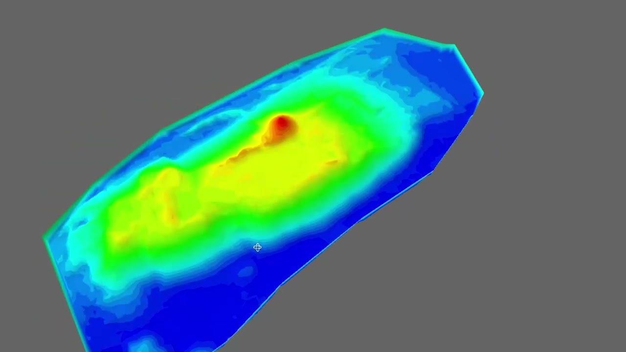
Quick floorplans with high-precision
With Pointorama, creating floorplans from point clouds becomes precise, efficient, and fast. It allows users to choose specific surfaces to match different terrains—whether flat or angled an to outline areas with polygons. For example, Pointorama can accurately map complex surfaces, like a sloping pool floor, which would typically be challenging and time-consuming.
This streamlined process ensures that floorplans are generated rapidly without sacrificing accuracy. Contractors and surveyors receive reliable, high-quality data without the need for extensive manual adjustments. By enabling users to quickly produce detailed layouts, Pointorama supports projects that demand both speed and precision.

Easy to master, ready to use
Pointorama is built specifically with contractors in mind, offering a straightforward and intuitive interface that lets users get started without needing extensive training. During business hours, support is readily available, ensuring that any questions are quickly resolved, which means contractors can start capturing and managing site data on their own terms.
This ease of use empowers contractors to perform accurate measurements, like assessing soil intake and removal, directly from the job site. By using Pointorama, contractors gain control over essential tasks that might otherwise require waiting for a surveyor, saving both time and money. With Pointorama, there’s no need to rely on outside help or face costly delays – everything you need is right at your fingertips, enabling you to complete tasks efficiently and keep projects on track.

Vendor-neutral flexibility
One of the standout features of Pointorama is their vendor-neutral approach. The software is designed to be compatible with a wide range of 3D scanning equipment and surveying instruments. This flexibility allows users to integrate data from various sources without being tied to specific brands or systems, ensuring that you can use your existing tools and technologies effectively. This adaptability not only simplifies the workflow but also makes it easier to switch between different hardware or software options as project needs evolve.
Conclusion
Pointorama’s integration of 3D scanning empowers construction professionals to enhance accuracy and efficiency significantly. Its user-friendly features and advanced floorplan capabilities make it an essential tool for contractors. The vendor-neutral approach allows users to seamlessly combine various tools and technologies, promoting a smoother workflow. By adopting this technology, projects can be executed more effectively, while also raising standards and quality within the construction sector. Ultimately, Pointorama supports more precise and flexible work methods, leading to improved project outcomes and overall success.
Ready to elevate your construction accuracy?
Leverage the power of 3D scanning with Pointorama. Boost efficiency and streamline your workflows today.
Explore your options Start your trial
Want to go deeper?
Dive into the fundamentals of indoor mapping and better understand the technology behind the workflow.
Download our free white paper and discover how scanning, point clouds and floor plan generation come together.
Related articles
Pointorama introduces AI-powered floorplan generation
Pointorama introduces AI-powered floorplan generation, allowing users to automatically create editable floorplans from point cloud data in seconds while keeping full control over every detail.

Pythagoras on tour: meet us at key events in 2026
Meet Pythagoras at key events in 2026. Discover new features, explore innovations and connect with our team across Europe. In 2026, Pointorama will be present at leading geospatial events across Europe, including GeoBusiness, Intergeo and Trefdag Digitaal Vlaanderen. Discover our latest innovations, explore new workflows and experience how much our technology has evolved when you meet us in person.

Launch your own branded CAD solution with Pythagoras BV
We have launched a powerful white-label CAD platform that enables drone and mapping companies to offer advanced CAD tools fully under their own brand — tailored to workflows, integrations and regional compliance.