Introducing Pointorama: a revolutionary platform for point cloud processing
Today marks a new chapter for surveyors, construction workers, and engineers with the official launch of Pointorama, a cutting-edge point cloud platform designed to transform the way professionals manage, analyze, and share spatial data. Built to streamline workflows and enhance precision, Pointorama is set to redefine point cloud processing with its intuitive tools and AI-powered features.
Four steps to effortless point cloud management:
At the heart of Pointorama lies a simple yet powerful four-step process that makes point cloud workflows more streamlined than ever:

Scan & upload
Effortlessly capture detailed measurements of landscapes, buildings, or environments using modern 3D scanning technology. Registration software then processes these raw scans into usable point clouds, ready to upload into Pointorama. This streamlined process allows professionals to focus on analyzing data instead of grappling with collection complexities.

Clean & classify
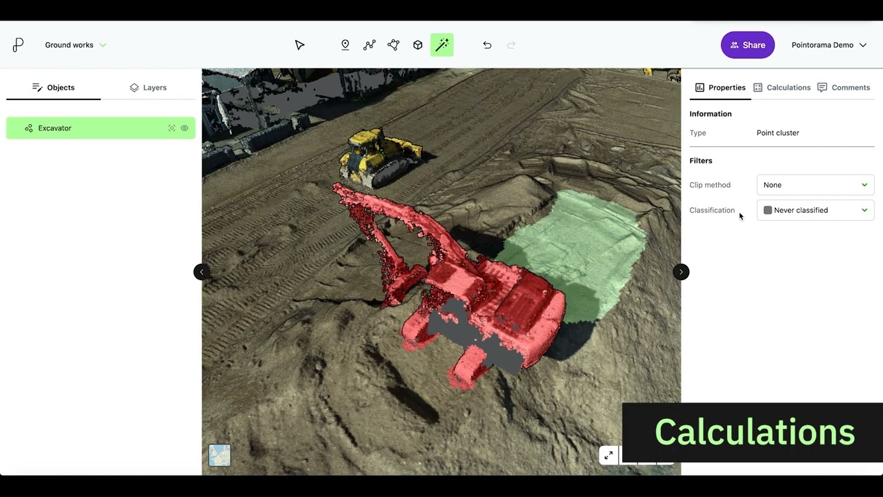
Clean, high-quality data is crucial for accurate results. With Pointorama, users can easily remove noise, outliers, and reflections, ensuring only relevant data remains. Advanced AI-powered classification object detection tools group and categorize objects, streamlining workflows, saving time, and reducing errors for reliable, precise outcomes.

Measure & map
Pointorama makes interpreting and analyzing point cloud data straightforward. Accurate measurements, object detection, and classification are at your fingertips, enabling you to create detailed and reliable outputs. Whether you’re mapping intricate interiors or expansive outdoor spaces, Pointorama delivers the precision and efficiency professionals need.

Share & Export
Easily generate and share high-quality insights, detailed reports, or DXF files compatible with CAD workflows, ensuring smooth collaboration with clients and team members. By simplifying the exchange of data and insights, Pointorama keeps projects on track, eliminates communication bottlenecks, and allows your team to stay focused on delivering exceptional results.

Why Pointorama is a game-changer
Pointorama was developed to address the challenges professionals face in managing and processing point cloud data. It combines intuitive functionality with powerful features to ensure you achieve accurate, actionable results without unnecessary delays or errors.
From cleaning and classification to measuring and mapping, Pointorama supports professionals at every stage of their workflow. It’s more than just a platform—it’s the future of point cloud processing.

Advanced tools to boost your productivity
Pointorama comes equipped with powerful tools like Object Detection and Classification to make your workflows faster and smarter. With Object Detection, you can quickly identify and highlight important features within your point clouds, while Classification allows you to group and categorize objects for better organization and analysis. Once your data is ready, export it effortlessly to formats like DXF, enabling seamless integration with CAD software and other tools. These features ensure that Pointorama not only simplifies your projects but also empowers you to deliver precise, professional results every time.

Ease of use with unmatched support
Pointorama is designed with simplicity in mind, ensuring that both beginners and experienced professionals can navigate its intuitive interface with ease. The platform streamlines complex workflows, letting you focus on delivering results instead of struggling with complicated tools. And if you ever need assistance, our dedicated support team is available during business hours to answer questions, provide guidance, and resolve any issues. With Pointorama, you’re never on your own—we’re here to help you succeed every step of the way.
Step into the future of point cloud processing
We’re excited to officially launch Pointorama and invite you to experience its full potential. Contact us today for more information or to schedule a demo and discover how Pointorama can transform your projects.
The future of point cloud processing starts now—don’t miss out!
Start your free trial Book a demo
Want do go deeper?
Dive into the fundamentals of indoor mapping and better understand the technology behind the workflow.
Download our free white paper and discover how scanning, point clouds and floor plan generation come together.
Related articles
Pointorama introduces AI-powered floorplan generation
Pointorama introduces AI-powered floorplan generation, allowing users to automatically create editable floorplans from point cloud data in seconds while keeping full control over every detail.

Pythagoras on tour: meet us at key events in 2026
Meet Pythagoras at key events in 2026. Discover new features, explore innovations and connect with our team across Europe. In 2026, Pointorama will be present at leading geospatial events across Europe, including GeoBusiness, Intergeo and Trefdag Digitaal Vlaanderen. Discover our latest innovations, explore new workflows and experience how much our technology has evolved when you meet us in person.

Launch your own branded CAD solution with Pythagoras BV
We have launched a powerful white-label CAD platform that enables drone and mapping companies to offer advanced CAD tools fully under their own brand — tailored to workflows, integrations and regional compliance.